
2027-B28 AI-Enhanced Global Hydrological Modelling for Assessing UK Water Security Threats
PROJECT HIGHLIGHTS
- A major improvement to UK capability to quantify threats to water security from a global perspective.
- Intersects contemporary AI technologies with observational datasets from satellites and land monitoring to produce new understanding on hydrology processes.
- An exciting opportunity for a DR to work with UK and international collaborators on a project that is of national and global significance.
Overview
Global hydrology models (GHMs) play a crucial role in understanding threats to water security. Their global remit means they can be used to assess transboundary impacts from water security crises, e.g. how flooding in East Asia might affect UK supply chains. They also help with quantifying cascading climate change risks, such as how a drought can lead to reductions in crop yields, which in turn lead to rises in food prices, and migration. The UK faces multiple environmental, economic and political threats from around the world. Water is one of these primary risks because it is associated with flooding, droughts and long-term water security, and can affect large land areas and multiple sectors of the economy, from days to years at a time.
Despite the importance of understanding the implications of global hydrological change for the UK and its security, there are only two GHMs in the UK’s environmental modelling national capability. One of these is JULES (the Joint UK Land Environment Simulator), which is a community land surface model that is used both as a standalone model and as the land surface component in the Met Office global climate model. However, whilst JULES includes complex representation of physical land surface environmental processes and feedbacks, its representation of direct human forcings on the hydrological cycle, such as dams, reservoirs, and water abstraction for different water users (e.g. agriculture, industry and domestic) is still being developed. The other model is MacPDM, which was originally developed at UKCEH and has undergone several updates over the past few decades, including several by this project’s supervisor (Gosling & Arnell, 2011; Müller Schmied & Gosling et al. 2024). However, just like JULES, MacPDM does not currently represent direct human forcings. Other national modelling infrastructure capabilities include these important aspects of the global hydrological system, such as WaterGAP (Germany) and H08 (Japan).
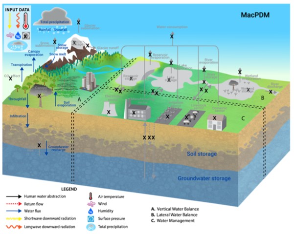
This project will provide an important update to the UK’s ability to simulate global hydrological risks and their impacts by using AI methods with global observation datasets to develop, test and optimise the parameterisation of direct human forcings in the MacPDM global-scale hydrological model.
Figure 1. The project will add the missing processes (in grey) to the MacPDM global hydrological model. From Müller Schmied & Gosling et al. (2025).
This project is a CENTA Flagship Project.
Case Projects
This project does not offer a CASE studentship
Host
- University of Birmingham
Theme
- Climate and Environmental Sustainability, Dynamic Earth
Supervisors
Project investigator
- Prof Simon Gosling (s.n.gosling@bham.ac.uk)
Co-investigators
- Dr Shasha Han, University of Birmingham (s.han.2@bham.ac.uk); Dr Andrew Hartley, Met Office (andrew.hartley@metoffice.gov.uk); Dr Helen Baron, UKCEH (heron@ceh.ac.uk)
How to apply
Each host has a slightly different application process.
Find out how to apply for this studentship.
All applications must include the CENTA application form.
Methodology
Model development: AI parameterisation learning methods (e.g. using Claude Code) will develop a new, consensus-based conceptual parametrisation scheme (not black box) informed by laws of hydrology and direct human forcing parametrisations from a large ensemble of GHMs, including WaterGAP and H08.
Optimisation and validation: The new parametrisations will be optimised iteratively for dams and reservoirs, then agriculture, industry and domestic water abstractions. Optimisation involves comparing the new simulations to satellite-derived reservoir storage products like Global Reservoir Storage (GRS), land-based estimates of streamflow (e.g. Global Runoff Data Centre, GRDC) and terrestrial water storage (e.g. GRACE). The parametrisations will be compared bilaterally with those being developed for JULES, in collaboration with the Met Office and UKCEH.
Application: Run the new model with CMIP7 climate projections to assess implications of water security threats to the UK, e.g. identifying future drought hotspots in world regions where the UK relies significantly on supply chains.
Training and skills
Partners and collaboration
Possible timeline
Further reading
Further details and How to Apply
For any enquiries related to this project please contact Prof Simon Gosling (s.n.gosling@bham.ac.uk).
To apply to this project:
- You must include a CENTA studentship application form, downloadable from: CENTA Studentship Application Form 2027
- You must include a CV with the names of at least two referees (preferably three) who can comment on your academic abilities.
- Please submit your application and complete the host institution application process via: https://admissions.bham.ac.uk/course-finder-landing-page/?code=LES068 Please select the PhD in Geography (CENTA) 2027 entry year Apply Now button. The CENTA Studentship Application Form 2027 and CV can both be uploaded to the Personal Statement section of the online form. In the funding section of the online form please select Research Council Funding and then choose Natural Environment Research Council (NERC). Please quote CENTA 2027-B28 when completing the application form.
Applications must be submitted by 23:59 GMT on Wednesday 6th January 2027.